
The DDTs have a great series of caches at the various peaks in Wellington Park. Unfortunately, most of Wellington Park – especially the higher altitudes – is now banned to dogs. So we’ve only done one cache in the series so far as Dog Guilt – the guilt felt going on a fantastic bushwalk while your dog stays at home – has kept us away. Last weekend we thought we’d do a cache or two in the series as Lottie has stitches from her grass seed incident, however a new Teva related blister meant we wound up doing some short walks around Mt Nelson instead. With a long weekend due to a local holiday (Regatta Day), Scott declared Saturday a day of rest, then Sunday we planned to hit a couple of these caches. So today was the day for Mt Connection.
 For those unfortunate enough not to live in Hobart or know the area, Hobart is basically squeezed between Mt Wellington (known locally simply as ‘the mountain’) and the Derwent River. Hidden behind Mt Wellington to the north and west are lots of other ridges and peaks. This walk would take us ‘behind’ the mountain to that hidden area.
We parked at the car park before the last snow gate before Mt Wellington’s summit. As we were getting out of the car, one of the bus/trailer combos that hauls bikes up the mountain pulled in and deposited humans and mountain bikes. As it happens they were headed for the same track we were starting off on, Big Bend Track, however they were gone by the time I’d taken a few flower photos at the start of the track.
The two main ways to get to Mt Connection are either from Big Bend or from Myrtle Park/ Collinsvale. Today we decided to go from Big Bend as we also wanted to hit another 2 caches, one at Tom Thumb and one not far from the Lost World. It was a beautiful day for walking at high altitude; the air was cool, but the sun was hot. (Maybe a little too hot!) There’s almost always a stiff breeze or gale on top of Mt Wellington, however today there not much wind at all.
The high alpine terrain is a little different from others we walk in more often. The plants are shorter and often there is more water on the ground – or at least in the Wellington ranges. It seems the terrain is either sloping off steeply or forming almost plateaus, and on these plateaus water gets caught. It makes for a different variety of plant life (like cutting grass – oh joy) and sometimes some difficult walking. I was interested to see a cross section of the soil while on the Big Bend Track. The top layer (about a foot deep) is dark, rich and holds water; below that is sandier soil. Of course both layers have lots of rocks. The Big Bend track cuts right through the rich top layer of soil; most other tracks (foot tracks) on top of the mountain do not. Trail maintenance tries to lessen the impact of walkers on the environment, with stones being arranged to form the track or even duckboard being placed in wetter sections.
 The Big Bend Track is wide enough in most parts to be a rough fire trail. The track takes you through a shoulder between the Thark Range and the knob above Lost World. After the shoulder, it soon descends sharply. To get to Mt Connection, you join the Collins Bonnet Track. The track is a foot track, which is welcome after the wideness of Big Bend. There’s lots of water under foot, so a bit of rock hopping is involved at some points. The track starts off fairly level and running sort of parallel to the Thark Range (to your left). Then the track to Collins Bonnect turns right down into the shallow valley that divides Thark Ridge and the ridge that is capped by Mt Connection. As you go into the valley, the track is either rock hopping or duckboard. Lots of water. On the other side of the valley, the track is mainly boulder hopping. It goes through a shoulder in the ridge, then turns left along Mt Connection. Here you’re on the opposite side from where you approached, so have views across to Sleeping Beauty and Collins Bonnet.
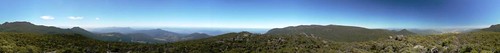
The Collins Bonnet track makes its way along the ridge and just below the summit of Mt Connection. The cache notes said there would be cairns on the left of the track showing the route to the summit. It was hard to determine what was a fallen rock cairn and what was just a pile of rocks, so we eventually just left the track and made our way to the top. The views were fantastic!
 There was even a welcome bit of breeze. We found the cache quite easily before returning to the track. (I sent a photo of Sleeping Beauty to twitpic from the cache site.) Back on track and I came across what I think was my favourite flower of the walk, a Feather Heath. I’m completely certain my liking the Feather Heath wasn’t influenced at all by finding out when I’d gotten home that my photo was MUCH better than those in my wildflower books. I’m not that sort of person at all. (Besides, the photos in my wildflower books aren’t great. Often out of focus, and often not including any leaves or even a clear look at the centre of the flower. Often makes identification impossible.)
During the walk, I photographed lots of flowers. Lots. We noticed that as we were walking we’d come across one sole new flower, photograph it and make much of it, then not much further on we’d come across a large patch of the same flowers. So if you’re a bit of a narcissistic flower, make certain you’re on the edge of the group and along a track. You’re much more likely to be photographed that way.
The track back was a return journey via the way we’d come out. Unfortunately the late start and frequent stopping to photograph flowers meant we would have to pass on going to Tom Thumb or the other spot we wanted to get to before heading off. Back on Pinnacle Road, I headed out to a puzzle final, then we were headed back down the mountain. We’ll be back again for anther dose of Dog Guilt soon!
Walk to Mt Connection
2 comments for “Mt Connection”