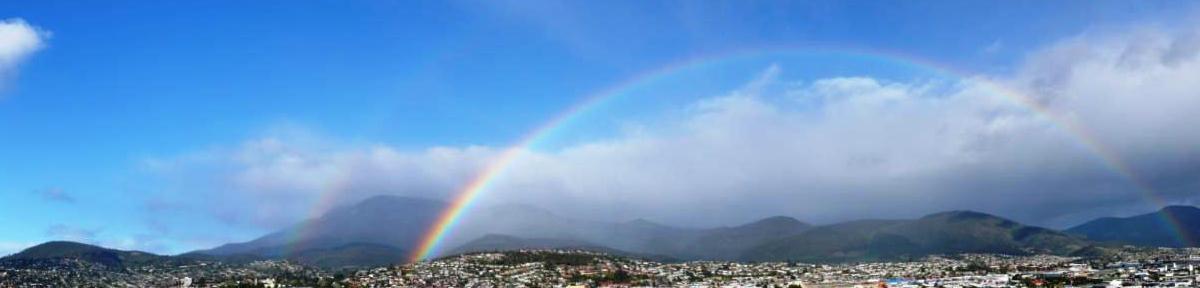
I thought we would NEVER get here! I didn’t sleep well and hadn’t been feeling well, so I got up not long after 7am and went up to brekkie. Checked my GPSr; still 57 kilometres from Easter Island. Dad and TS came up, and TS suddenly realised that although at a distance we could see the island in front of us! We anchored around 9.30am, but it took time for officials to clear the ship, pilots for the tenders to come out, etc blah blah blah. Then tour groups went ashore, then they finally started calling tenders – we were on tender 2. The tender went through some extremely high sells, and I was happy to see that we had local pilots on board.
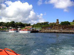
We finally got ashore at Hanga Piko Cove at noon, and after all the waiting and waiting we were suddenly on the island and in the middle of chaos! Everything was happening at once – bewildered passengers just off the tenders just staring at everything while they tried to decide what to do, food and souvenir stalls, and taxis vying for everyone’s attention to take people around the island.
We wound up making quick decision was made to take a US$150 taxi ride around the island. First we drove through town to Ahu Tahai, a site with 3 ahus almost in town.
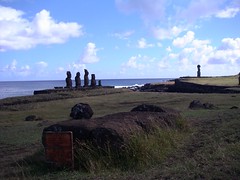
One of the ahus had several moai, two had just one moai (including the only moai on the island to have its eyes restored, Kote Riku – the eyes are made of white coral and black obsidian). There was also a boat ramp and remains of hare paenga – long-boat shaped houses. When we had gotten of the tender, it was sunny, however by the time we were at this ahu it was clouding over and sprinkling a bit. (We came the next day and saw it in sun though!)
TS noticed our taxi driver, Antonio, had a tourist map, so she asked where we could get one. (TS was our expedition’s Spanish speaker, and she did a phenomenal job – SSOOOO much better than my horribly rusty French!) He stopped at the tourist information bureau on the way through town and got us a few maps; these were useful as they had some explanations of sites in English. We drove through town (Hanga Roa) and into the countryside to Ahu a Kivi (also known as the 7 moai). On the way there we noticed guava growing next to the road, and dad was interested in the birds.
When we reached Ahu a Kivi and got out of the taxi, I think I was most struck by finally being away from people and noise. We were there alone, and it was quiet enough to hear the birds and see the moai without dodging other people. We took some photos of travel bugs here as well as the Geocaching Australia bumper sticker. The clouds were beginning to break up.
The sun broke through the clouds on the drive across the island to Bahia de Anakena (Anakena Beach). As you drive around Easter Island, much of the roads are ruff red mud and clay. There are quite a few feral horses, often standing in the roadway for some reason. Cars have a sort of buzzer that is supposed to startle them out of the way. Taxis are anything with 4 wheels and a sticker on the side declaring them to be a taxi – the local cab company’s sticker of course has moai. Both the taxis we used – this and the one the following day – had read dust in every possible crevise. Dad as the biggest got in the front the 3 ‘girls’ squished in the back.
Anyway, back to the drive to Anakena! The drive took us through some eucalyptus groves. Not far from Anakena Antonio stopped the engine and said we were at a ‘magnetic’ place on the island where cars would coast uphill by themselves. To be honest none of us were too impressed; it was difficult to judge whether we were going uphill or downhill really.
Unlike our brief visit to Ahu a Kivi, Bahia de Anakena was quite busy as well as clear and sunny.
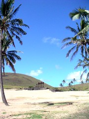
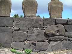
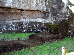
The car park was full, and there were many tour groups there having their BBQ picnics at table under palm trees. It is a lovely white sand beach, and there are 2 ahu, Ahu Nau Nau probably being the most spectacular as it had 7 moai, 4 of these with the red top knots, and several of the moai were so well preserved that you could see the traditional tattooing carved on them. This fine detail was well preserved as the sand here was soft, so when they fell or were thrust down from the ahu they would have quickly been covered by soft sands. Some of the blocks that make up the ahu have faces carved in them (perhaps moai that broke?) and tangala moko (lizard men).
This ahu is also the one that Thor Heyerdahl restored. The other ahu at this site is Ahu Atare Huki, which just has one moai. This moai was the one lifted by Lazaro Hotus and Pedro Atan to demonstrate the method for Thor Heyerdahl.
I walked up the slight hill under the palms to take a photo, as did dad, then up the high hill Anakena Cave is on and took photos from above. It is legend that this is where people first arrived on the island.
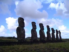
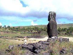
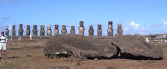
Our next stop was Ahu Tongariki, a BIG ahu with 15 moai as well as a few other moai scattered around on the surrounding ground.
Inland and near the main road there were petroglyphs, Papa Tataka Poki, which we found thanks to the tourist maps we had. There were representations of honu (turtles), ika (fish), and tangata manu (bird man). The petroglyphs could be hard to see, but as the sun was getting lower in the sky some were visible and photographable.

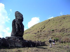
The quarry at Volcan Rano Raraku was our next stop; this is at a distance from but within site of Ahu Tongariki. We made quite an entrance to the car park; the taxi hit bottom! However the driver seemed much less concerned than we were! I was really surprised that TS and dad stayed near the car park and didn’t venture up to the quarry; this was just fantastic! There were just so many moai, many only partially completed and still part of the rock.
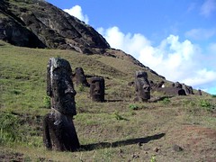
I wanted to walk to the top, however I noticed mum was coming up the hill. She doesn’t do hills or walking very well at all, so I did a bit of reconnaissance and scoped out where she could take a short cut and get the most from the walk uphill – got her onto a path with lots of moai on either side as well as 3 or 4 that were still part of the rock. This was our last stop before being dropped back off at Ana Piko Cove and taking a tender back to the ship.
This was a fantastic day! I had been feeling quite ill and hadn’t slept well the night before, but I felt fabulous at the end of the day! My shoes were full of Rapa Nui mud, my caching trousers were red with it, and my shirt was definitely in need of a wash (after being at sea, these things are exciting – trust me!) – but I was very happy! I had a shower, then headed for the Lido Deck for a gin & tonic. TS met me up there, and we watched the Rapa Nui dancers until we had to get down to dinner. We found out Bernie at table 42 is a geocacher, so while I was having my SD card burnt to CD, TS made arrangement to meet up the next day to hopefully attack the caches on the island. YEAH!!